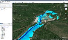
Interactive Flood Risk Map
Skip to content
When autocomplete results are available use up and down arrows to review and enter to select. Touch device users, explore by touch or with swipe gestures.
Log in
Sign up
Explore
Interactive flood risk map
Discover Pinterest’s best ideas and inspiration for Interactive flood risk map. Get inspired and try out new things.
Last updated 17h
Related interests
Flood Zone Map Usa
Urban Flood Risk Assessment
Flooded World Map
Flood Level Chart
Flood Timeline
See more
Interactive flood risk map and more
Explore related boards
thesis
tyler flo
,
501 Pins
·
,
2mo
Graphic design tutorials
Thomas Ray
,
236 Pins
·
,
3w
thesis proposal
William Obert
,
104 Pins
·
,
2y
PGC posters
Rhian Jones
,
10 Pins
·
,
2y
Infographics
Community Impact Newspaper
,
24 Pins
·
,
10y
See more
Flood Risk Map 2023
Flood Risk Management Project Diagram
Annual Flooding Risk Map
Flood Risk Analysis Chart
Flood Risk Map By State
City Flood Risk Analysis
Floodplain Risk Map
Flood Risk Visualization Diagram
Urban Flood Risk Map
Flood Risk Map 2023
Flood Zone Map
Pre Flood Map
Flood Zone Mapping
Historical Flood Map
Great Flood Map
Flood Diagram
Map Of The Great Flood
Flood Elevation Map 1996
Historical Flood Control Map
How deep could your home flood? See Sacramento’s ‘ultimate’ flood map
Oregon City
Oregon City Flood Insurance Rates
Oregon City Flood Plain Map
Oregon City Flood Zone Map
Oregon City Flood Zone Map Pdf
High Water Map Portland Oregon
Oregon Flood Map
Sea Level Rise Oregon Map
Map Of Portland Oregon Flooding
Flood Map: Water Level Elevation Map
Flood Disaster Response Planning
Flood Risk Management Strategies
Flood Risk Management Project Diagram
Flood Prevention Educational Material
City Planning For Flood Resilience
Annual Flooding Risk Map
Community Flood Resilience Strategies
Flood Resilience Action Plan
Flood Resilience Strategy
Flood Resilience Game for flood-prone communities
How To Analyze Flood Maps
Hydroelectric Dam Simulation
Reporting Flood Impacts Effectively
River Flood Prediction Tools
Flood Susceptibility Analysis Tutorial
Monitoring Flood Risk Areas
Geospatial Technology Flood Prevention
Historical Flood Analysis Tool Map
Hydroelectric Dam Infographic
Page Not Found – CivilGEO | Stormwater & Hydraulic Modeling Software
Water Map
Pre Flood Map
Flood Zone Mapping
Great Flood Map
Map Of The Great Flood
Flood Elevation Map 1996
River Flood Diagram
Fema Flood Maps
Historical Flood Analysis Tool Map
ArcNews Fall 2002 Issue -- Rhine Flood Hazard Mitigated With the Help of GIS
How To Read Flood Risk Maps
How To Find Flood Zones
Understanding Flood Patterns
How To Analyze Flood Maps
Pre Flood Map
How To Read Flood Maps
Great Flood Map
Flood Plain Map For Construction
Map Of The Great Flood
Overview - Flood Maps
California Flooding Map
Coastal Flooding Map
Sea Level Rise California Map
Sea Level Rise Flooding Map
Coastal Flooding Infographic
Coastal Flooding 2050
Sea Level Rise Map 2050
Coastal Flooding Impact
Coastal Flooding Climate Report
Rising seas already overwhelm the Bay Area. Time is running out for California to act
Annual Flooding Risk Map
South East England Flood Map
2016 Flood Risk Map
Flood Risk Map 2008
Environment Agency Flood Protection
Flood Risk Assessment Example
Kent Flood Risk Map
Fema Flood Risk Map
Understanding Uk Flood Risks
[Withdrawn] UK floods 2014: government response and recovery
Urban Flooding Impact Analysis
Mapping Flood Forecasting Guide
Landmark Flooding Map
Historical Flooding Map Infographic
Historical Flood Analysis
Coastal Flooding Infographic
Documenting Urban Flooding
Historical Flood Control Map
Documenting Urban Flooding Impacts
Urban Flooding Impact Analysis
Philippines River Map
Manila Cartography Map
Manila City Map Coastal
Manila Bay Map
Manila Bay Philippines Map
Future Flooding Map
Map Of Manila Bay Area
Map Of Manila Bay
Philippines Coastal Map
Philippines River Map
Flood Zone Map
Flood Zone Mapping
Fema Flood Zone Map
Norfolk Flood Map
Historical Flood Control Map
Flood Vulnerable Areas Map
Fema Flood Maps
Flood Risk Map 2008
Ipswich Flood Map
Flood Zone Map
How To Analyze Flood Maps
Mississippi River Flood Stage Map
How To Read Flood Maps
Fema Flood Maps Mississippi
Fema Flood Zone Map Mississippi
Historical Flooding Map Infographic
Coastal Flooding Infographic
Infographic On Flood Risk Management
Flood Fact Infographic
How To Analyze Flood Maps
Flooding Diagram
Urban Planning Flood Prevention
Floodable Architecture
Infrastructure Planning For Floods
Flood Architecture
City Planning Flood Prevention
Urban Flooding Analysis
Diagrams Of Flood Protection
Flood Protection Diagram
Flooding Diagram
Flood Diagram
Flood Diagram Easy
Flood Diagram For Kids
How Does A Flood Happen
What Causes A Flood
Floods Geography
Understanding Flood Models
Floods In Geography
Flood Diagram
Future Flooding Map
London Flooding Map
England Flooding Map
Mapping Flood Forecasting Guide
London Flood Warning Map
South East England Flood Map
Future Global Flooding Forecast
Sea Level Rise Map Uk
London Flood Risk Map
Future Flooding Map
Pre Flood Map
Historical Flood Map
Flood Zone Property Map
Great Flood Map
Boston Flooding Map
Fema Flood Zone Map
Coastal Flooding Map
Boston Flood Zone Map
Historical Flood Control Map
NorthEndWaterfront.com
Flood Relief Strategies
Flood Recovery Strategies
How To Design Flood Resilient Cities
City Flood Management Strategies
City Planning For Flood Resilience
Flood Resilience Strategy
Urban Flooding Situation
Flood Resilient Urban Design
Urban Planning For Flood Resilience
Creating a flood resilient city: Moving from disaster response to disaster resilience in Ibadan
Understanding Flood Impact On Cities
How To Design Flood Resilient Cities
Urban Flood Protection Plan
How To Prevent Flooding In Cities
City Flood Management Strategies
How To Reduce Flood Risk In Cities
Urban Planning After Floods
City Planning For Flood Resilience
Infrastructure Planning For Floods
5 critical ways to protect cities from disastrous flooding
Cityscape Design Inspiration
Detailed Architectural Blueprint
Modern Urban Planning Layout
Urban Development Project Ideas
Urban Landscape Design Plan
Planning For Flood-prone Areas
Infrastructure Planning For Floods
Coastal Flooding Map
Historical Flood Levels
Memory Landscape