Urban Form
Skip to content
When autocomplete results are available use up and down arrows to review and enter to select. Touch device users, explore by touch or with swipe gestures.
Log in
Sign up
Explore
Urban form
Discover Pinterest’s best ideas and inspiration for Urban form. Get inspired and try out new things.
494 people searched this
·
Last updated 1d
Related interests
Subtractive Architecture
Street Urban Design
Urban Modern
Urban Nature
Urban Spaces Design
See more
Urban form and more
Explore related boards
Bitirme 🧿✨
dlsddiana
,
74 Pins
·
,
21h
architecture
e.tinuoye
,
1.5k Pins
·
,
27m
urban planning
Xrush Ntampakaki
,
214 Pins
·
,
1d
GD4
sara
,
118 Pins
·
,
22h
Landscape 2025
ReHam MohaNd MaLaa
,
204 Pins
·
,
1d
See more
Urban Planning Ideas For Cities
Urban Planning Concept Ideas
Urban Design Concept Ideas
City Street Layout Plan
Detailed City Street Layout
City Street Layout Diagram
Urban Planning Concept
Creative Urban Planning Concepts
Urban Planning Software Ideas
Urban Planning Ideas For Cities
Urban Zoning Diagram
Zoning Diagrams In Architecture
Zoning Architecture Diagram Plan
Zones Diagram
Zone Diagram Architecture
Zoning Site Analysis
Architectural Site Map Diagram
Zoning Diagram
Map Analysis Architecture
Urban Zoning Diagram
Circulation Maps
San Francisco Map Blueprint
Black And White Traffic Diagram
Sacramento Retro Urban Blueprint Map
Urban Grid Layout Diagram
Circulation Map Architecture
Circulation Analysis Architecture
Urban Circulation Diagram
Gray San Francisco Map
Circulation Maps
Architecture Analysis Diagrams
Urban Planning Ideas
Urban Design Graphic
Urban Grid
Urban Design Concepts
City Render
Street Mapping Urban Design
Urbanism Architecture
Urbanism Concept
Architecture Analysis Diagrams
City Street Map Detail
Urban City Map Details
Urban Map / Street Map
City Planning Data Analysis
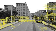
How To Analyze Urban Data
Analyzing Urban Planning Data
Urban Planning Data Analysis
Modern Urban Map Patterns
Urban Data Mapping
mapping architectural
Urban Design Drawings
City Design Project
Urban Planning Map
Urban Design Ideas
Urban Design Aesthetic
Site Location
Urban Planning Diagram Concept
Urban Diagram Architecture
Urban Space
Urban Design Drawings
Urban Map With Detailed Zones
Cityscape Analysis Tools
Urban Map With Color-coded Areas
Urban Planning Gis Diagram
Urban-maps City Map Collection
Qgis Urban Planning Map
Analyzing Urban Planning Maps
Urban Planning Map With Color-coded Zones
Arcgis Map
MIT's Free Urban Planning Software Will Help Build The Cities Of The Future
Urban Design Competition
Bauhaus Architektur
Urban Design Diagram
Architecture Drawing Presentation
Design Presentation
Urban Analysis
Urban Design Graphics
Urban Design Concept
Architecture Mapping
Location plan
City Map Builder
City Layout Generator
Fictional City Maps
City Grid Layout
City Planning Map
Cities Map
Big City Map
Cities Layout
City Plan Layout
City Map Builder
Plan Analysis Architecture
Urban Form Analysis
Nolli Map
Mapping Architecture Analysis
Urban Morphology Site Analysis Map
Projective Urban Planning Map
Mies Van Der Rohe Buildings In Chicago Map
Nolli Plan
Nolli Diagram
Public space as void / Urban void as a public space. IS IT ENOUGH?
Vertical City Map
City Map Evolution
World Population Density Map 3d
Population Density Map Example
Understanding City Demographics
Density Map Automatic City Coloring
Sustainable City Map
Urban Population Density Map
Color-coded Population Density
See how NYC's urban density stacks up against other major cities | 6sqft
Urban Planning City Layout
Urban Architecture Plan
Urban City Plan
Urban Planning Drawing
Urban Planning Examples
Urban Design Plans
Urban Planning Architecture
City Site Plan
Urban Design Concepts
Urban Design Projects Pdf Town Centre Regeneration Urban 883 A3
Board Diagram
Architecture Diagram 3d
Porosity Diagram
Big Architecture Diagrams
Concept Architecture Presentation Board
Urban Form
Morphology Diagram Architecture
Urban Isometric
Section Plan Drawing
Multifunctional urban complex - Sofia Yaremkiv
Green Urban Planning Inspiration
Green Landscape Urban Planning
Urban Parking Space Layout
Urban Plaza Design Plan
Landscape Design Square Plan
Urban Square Design Plan
Parking Landscape Plan
Plaza Landscape Design Plan
Public Plaza Design Plan
Green Urban Planning Inspiration
People, Movement and Public Space - Sebastiaan van Arkel
Urban Sprawl Diagram
Urban Form
Urban Transit System Map
City Map Analysis
Urban Planning Density Guide
City Planning Data Visualization
Urban Data Mapping
Urban Transportation Map Diagram
Urban Planning Research Data
Urban Sprawl Diagram
Urban Maps Architecture
Conway Quadrangle Topographic Map
Allentown Topographic Map
Urban Map Detail
Figure Ground City Map
Abstract City Map Layout
Paris Urban Map
Paris Map With Geometric Pattern
Urban Map Art Inspiration
Urban Maps Architecture
Urban Planning Layout
Urban Design Neighborhood Plan
Urban Development Plan Layout
Town Planning Layout
Modern Urban Planning Layout
New Urbanism Plan
City Planning Design Layout
Urban Town Planning Map
City Layout Plan
Related plans redevelopment of Metro Town Square mall in Santa Ana
Understanding Urban Patterns
Urban Maps Architecture
Cityscape Analysis For Urban Planning
Figure Ground Urban Design
Map Of Urban Street Intersections
Figure Ground City Map
Paris Urban Map
Detailed Urban Map Analysis
Urban Area Map Analysis
Urban Form Analysis with OpenStreetMap Data
Urban Planning Types
Urban Planning Diagram Concept
Modern Urban Planning Examples
Neighborhood Analysis
Urban Design Site Analysis Diagram
Urban Design Concept Diagram Ideas
Urban Planning Design
Urban Design Analysis Diagram
Urban Design Framework
Ameliorated Neighbourhood | Cept - Portfolio B83